Regional Planning for Climate Vulnerable Geographies: Understanding the Case of Kashmir Valley
by -
The Kashmir Valley, surrounded by the lofty Himalayas, has been sculpted by glacial flooding and the Jhelum River over thousands of years. Located at the center of the valley, Srinagar lies in a strategic yet ecologically fragile region that hosts a dense network of wetlands, lakes and other water bodies.
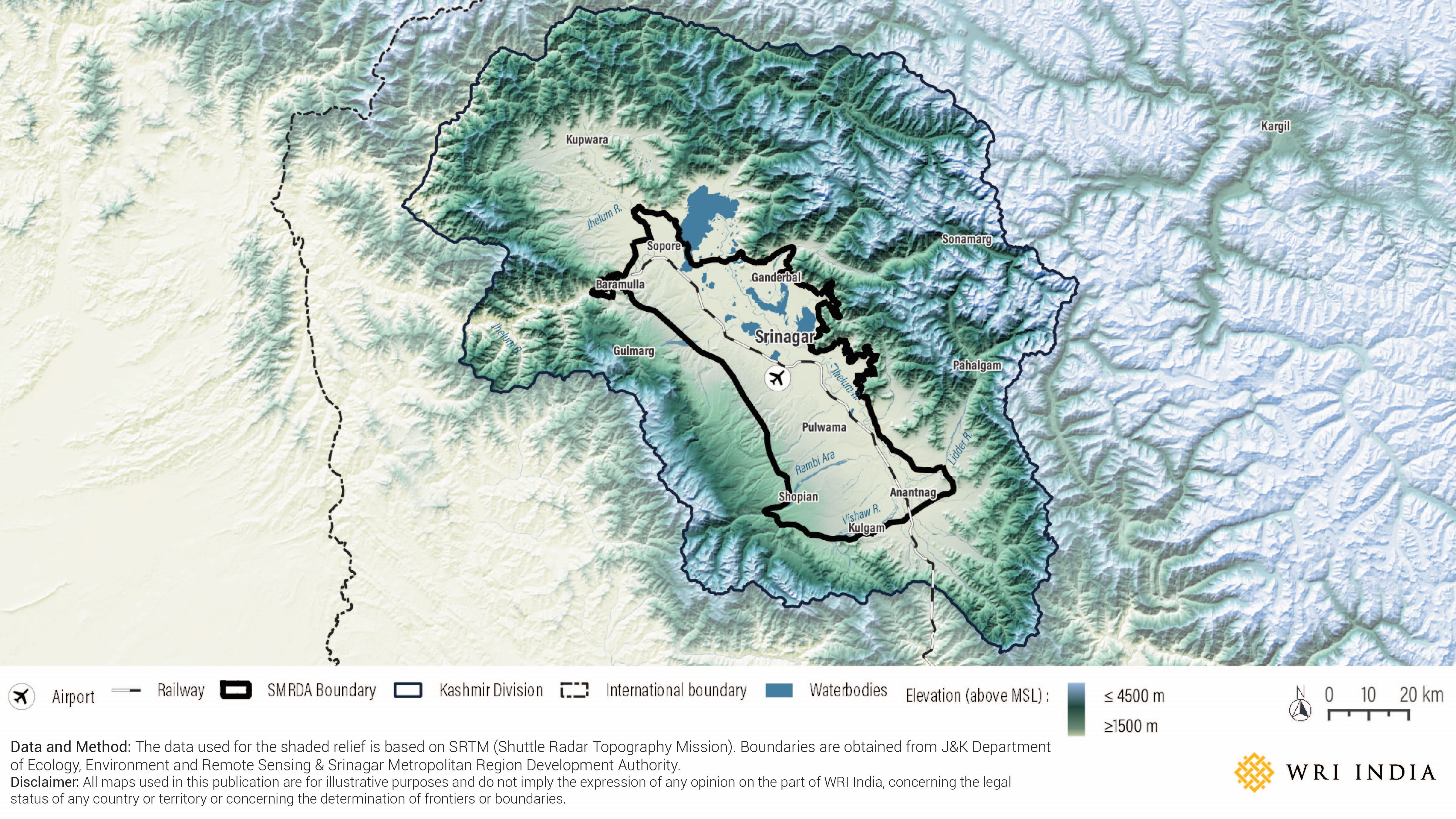
Historically, agriculture has been the mainstay of livelihood for a majority of the local population while its waterways served as transportation routes for the movement of goods, services and people. As a result, towns and villages grew in patterns that best served the predominantly rural economy, evolving along waterways and river navigation routes. Over time, the centrally located city of Srinagar became the economic and cultural center of the valley.
Over the past few decades, as the region’s agriculture-based economy transitioned towards a service-based urban economy, the need to live near these agricultural lands and waterways declined. Coupled with population growth, built-up areas expanded along arterial road networks, floodplains, and sometimes on prime agricultural and horticultural land. Over time, haphazard landfilling for construction of housing and urban services in the basin-shaped area has disrupted natural drainage. This has led to increased water logging, exponentially raising flood risk and incidence of extreme weather events. The floods of September 2014 exposed the vulnerabilities of the region, emphasizing the need for a cautious and structured planning process that can inform the region's development while accounting for ecological considerations.
Unique Geographical Profile of Kashmir Valley
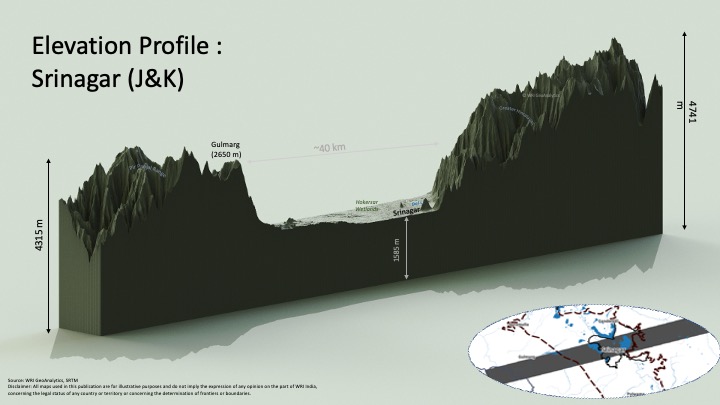
Kashmir Valley is an intermontane valley sandwiched between the high mountain ranges of Pir Panjal and Greater Himalayas. Additionally, it is landlocked, making it a multi-hazard region riddled with several environmental constraints.
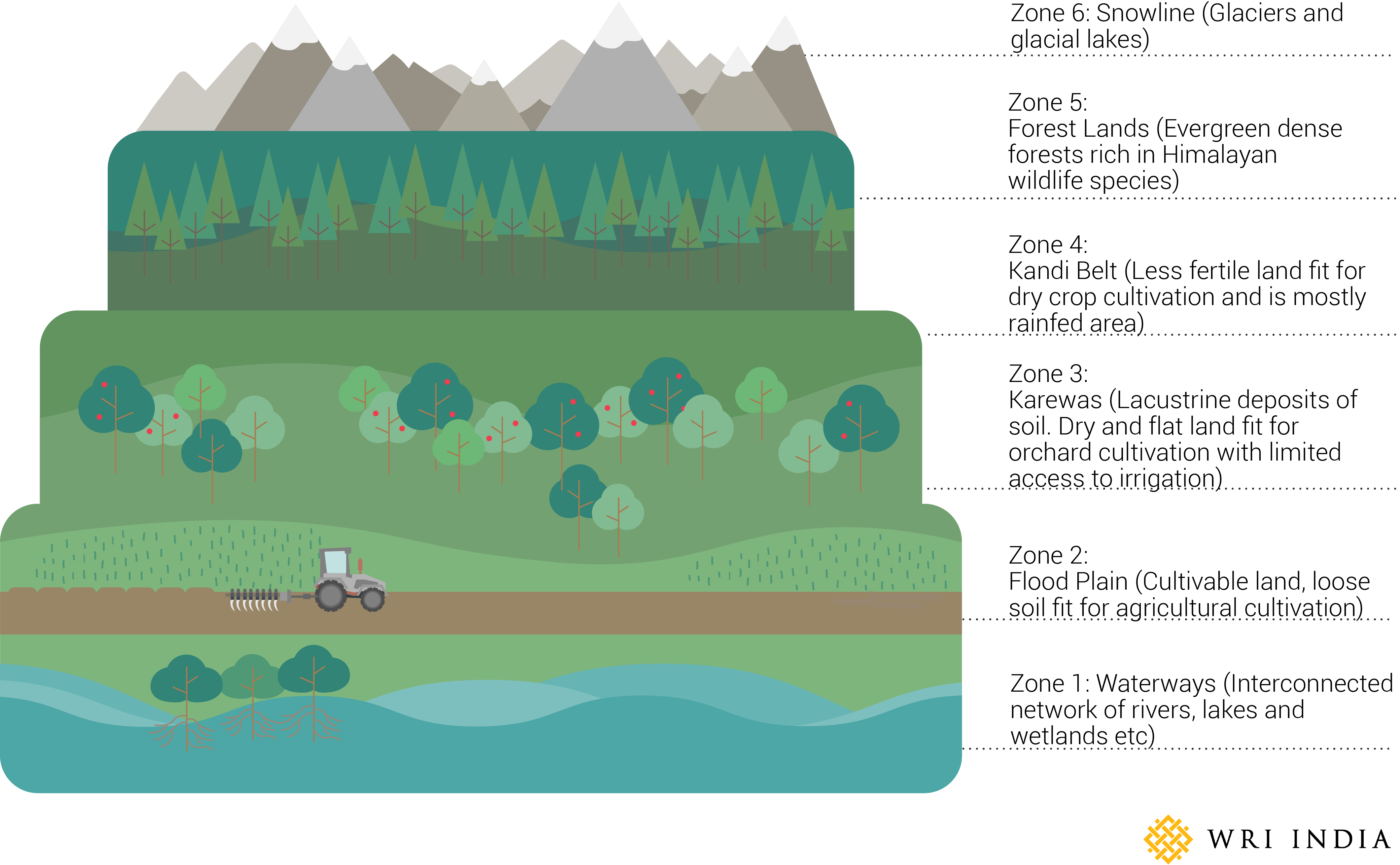
Geographic thresholds like mountains, wetlands and water bodies play a dominant role in shaping the settlement structure of the valley. The characteristics of the land vary at different elevations. On the valley floor – ground elevation of 5,000 feet (1524 meters) above sea level, – are waterways and cultivable land. Rising to 9,000 feet (2740 meters) and above are forest lands, above which lies the snowline with glaciers and glacial lakes. The graphic below depicts the six vertical elevation zones with differing characteristics of land.
The Urbanization Challenge
Rapid urbanization and rising pollution levels have degraded Kashmir’s environmental resources and continue to threaten its natural ecosystems. Between 1911 to 2011, the Kashmir valley lost nearly 50% of its wetlands. The presence and health of such natural assets don't merely shape ecosystem services but also play a crucial role in determining the availability of land resources for development, especially in and around commercial nodes such as Srinagar.
Even as Srinagar has retained its primacy in the region, a plethora of geographical constraints limit the availability of suitable land for its expansion. It further gets compounded by the extension of limits in areas that are either vulnerable to floods or ecologically fragile, thus limiting the supply of land for spatial growth.
Expanding existing areas will not just alleviate but also aggravate the problems of congestion and loss of natural resources. Kashmir’s large fertile lands support its economy through cash crops like apples, walnuts, almonds, saffron, etc. Unplanned urbanization, in the absence of a regional land-use policy, could have a long-term impact on prime agriculture and horticulture land banks, jeopardizing the region’s economic future. Food security challenges in this landlocked region are increasing at an alarming rate as fertile land is being converted into non-agricultural land for urbanization purposes. The alpine environment of the valley risks getting converted into a concrete jungle, which is bad for both the environment and the native population.
Regional Flows and Networks
Given the strategic location, challenges and potential of the region, Srinagar Metropolitan Region Development Authority (SMRDA) was created under Jammu and Kashmir Metropolitan Region Development Authorities Act, 2018. The SMRDA can offer an overarching institutional framework for the coordinated, orderly, and planned development of the Srinagar Metropolitan Region (SMR).
The new development initiatives for Srinagar city-region and surrounding areas of the valley must align with its regional flows and the dynamic network for circulation of people, materials and services in the region.
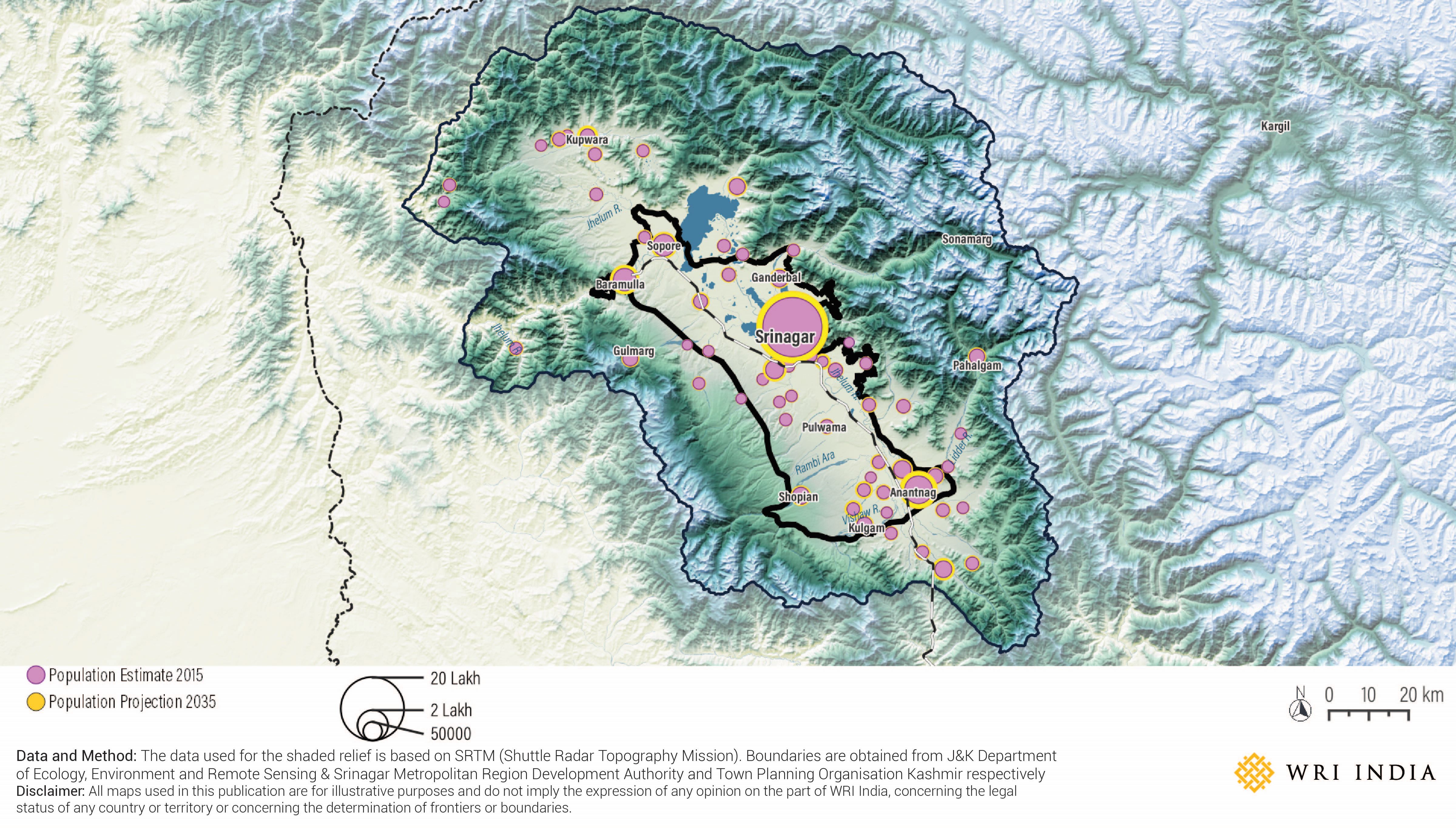
Unprecedented urbanization within the valley, particularly along the north-south axis from Anantnag to Baramulla via Srinagar, offers ample opportunities for new and sustained economic growth. In the regional settlement hierarchy pattern, the Kashmir Valley is witnessing the growth of three major urban nodes – the Srinagar Urban Agglomeration, Southern Urban Agglomeration (Anantnag Bijbehara-Mattan) and Northern Urban Agglomeration (Baramulla and Sopore). The population projections of different classes of towns in Kashmir Valley suggest that Srinagar will continue to hold its primacy in the region. However, the Class I and II towns are expected to contribute significantly during the next two decades.
This trend is healthy as the existing skewed urbanization is being balanced out by the growth of midsized towns as per the existing growth trend. Anantnag-Bijbehara-Mattan (ABM) agglomeration is estimated to have 6.5 Lakh population where Baramulla-Sopore Urban Agglomeration is estimated to have 4.75 Lakh population by 2035. This dispersion needs to be supported and reinforced in local planning and policy instruments to catalyze development of dormitory and satellite townships in the suburbs of Srinagar city. Additionally, promotion of regional countermagnets across the wider region of the Jhelum valley floor can aid in reducing demographic pressures on Srinagar city due to local migration.
Building a Regional Outlook for Sustainable Growth
A regional strategy for the Srinagar Metropolitan Region can aim to address the environmental concerns and urbanization issues at the regional level and play a vital role in guiding the Valley towards the sustainable future.
Urban planning in Srinagar must be integrated with the regional factors which play a key role in shaping urbanization and the settlement pattern of the valley. Addressing environmental concerns and urbanization issues at the city level requires appropriate planning measures at the macro scale. Such a scale would consider the Jhelum watershed a single planning unit with its cause-and-effect relationship to the valley.
The entire valley floor must be treated as a single macro planning region with North, South and Central Kashmir as major subregions for dovetailing its broad land-use policies in an integrated manner. This will not only help protect ecologically fragile areas from unabated urbanization but will also go a long way in the economic development of the entire region.
The rationale for planning and developing the Srinagar Metropolitan Region must carefully balance the complexities of the Kashmir region, including its fragile ecology, flood vulnerability, existing settlement patterns, and the need for affordable, sustainable transportation. An integrated approach can ensure that economic development and future growth occur within sustainable limits while preserving the region’s natural and cultural heritage. Comprehensive planning for this eco-sensitive region can help sustain the valley’s resources, protect its ecology, meet the aspirations of local communities and promote economic advancement.

