Battling Environmental Degradation

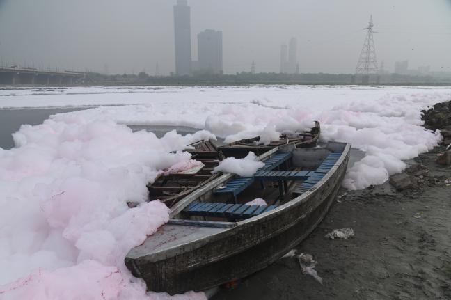
In October 1955, a major flood caused the Yamuna to shift course towards the Najafgarh channel, previously part of the Sahibi River. This led to contamination, as the Yamuna shifted near the sewage contaminated Najafgarh waters. Over the past few decades, untreated sewage and effluent outflows, alongside solid waste disposal, led to continuous degradation. Today, only 2% of the river length flows through Delhi yet the city is responsible for about 76% of the total pollution load in the river.
As per Ministry of Housing and Urban Affairs (MoHUA) guidelines, the benchmark for reuse and recycling of wastewater is 20% (service level benchmark for urban water and sanitation). However, in the case of Delhi approximately 12% of total wastewater generated is reused, the remainder is discharged into the Yamuna. Though the city's infrastructure is substantial, it encounters numerous challenges in effectively managing its water resources . Pollution source mapping and understanding the drain network is crucial for assessing and addressing the contamination in water bodies.
Delhi’s Drains
The drainage morphology of Delhi is largely defined by the Aravalli foothills and connected outcrops. Irrigation & Flood Control (I&FC) department classifies Delhi into six drainage zones: North, West, Central Northwest and Southeast, Central South and Southeast, East, and South. These zones encompass both natural drainage and engineered stormwater drains, with many of them conveying a blend of effluent and untreated sewage.
Like the Yamuna River's north-south bisection of the city, the Najafgarh drain cuts across Delhi from west to east. Contributing 60-70% of the pollution affecting the Yamuna, the Najafgarh basin, largest in the National Capital Territory (NCT) of Delhi, covers two-thirds of the city. It is accompanied by other drainage systems like the Barapullah basin and the Trans-Yamuna basin which have catchments spread over a region beyond NCT. Given the volumes of untreated wastewater they carry, all major drains act as continuous channels of waste, sludge, sewage and other pollutants, adversely impacting the river ecosystem and dependent habitation along the flood plains.
In addition to this continuous cycle of contamination, extreme weather events add further risk. Of late, the capital has witnessed increased incidents of floods. Since the 1900s, Delhi has experienced nine major floods, during which the Yamuna River has exceeded its danger level of 204.83 meters on 20 occasions in the past 33 years. Creating a deeper understanding of river ecosystems and concepts like “room for rivers” to restore the natural flood plains of rivers, is crucial for environmental sustainability and flood management in dense urban areas. By preserving the natural floodplains and wetlands, cities may be able to mitigate the risk of devastating floods while also improving water quality and biodiversity, fostering a healthier urban ecosystem.


