


From Local Risks to Local Planning for Rural Resilience
In the heartland of India, farmers are witnessing a new phenomenon — crops are failing, not just due to water shortages, but also due to heat and erratic rainfall. Local officials have noticed unseasonal rain that disrupts flowering, weakens grain formation and draws pests. Monsoon delays are also causing drinking water shortages as most people depend on tubewells.
Local communities are often the first to notice changes in the climate patterns that affect their lives and livelihoods. Alas, planning processes and budgetary allocations rarely integrate or reflect these community insights.
Diversity in Local Risks
Villages in Madhya Pradesh's Betul district are grappling with similar challenges. Spanning 10,043 sq.km, Betul features diverse landscapes, including dense forests, floodplains and the Satpura mountain ranges. Its diversity is accompanied by a range of climate risks like rising temperatures, rainfall variability and droughts, which manifest differently based on local biophysical characteristics. Heavy rainfall that causes flash floods in low-lying villages can lead to landslides in hilly regions. Yet, most climate data projections used for resilience planning rely on coarser resolution data like district-level estimates that mask variations within the district.
Climate impacts are affecting Teak forests in Madhya Pradesh's Betul
Workers and owners of wood and furniture MSMEs share their challenges as heat and flood pose occupational risks. Read here.
Participatory climate vulnerability assessments that combine granular climate data with local knowledge can help uncover such differences to develop targeted, locally relevant adaptation and resilience plans.
Bridging Gaps in Resilience Planning
In India, development planning largely follows fixed timelines, scheme guidelines and sectoral targets. State and district administrations anchor such processes and allocate resources, while block and line departments focus on implementation. This structure makes it difficult to systematically incorporate local climate risks into planning processes.
Development planning is also fragmented across sectors and departments. For example, under the Jal Jeevan Mission (JJM), panchayats are responsible for infrastructure, while the Water Resources Department is often tasked with the identification and maintenance of water sources. In Betul district, people continue to struggle for water during the summer months even in the villages where JJM pipelines are laid as groundwater levels decline due to inadequate measures to ensure groundwater recharge. Seeing departmental roles in isolation risks limiting their impact, since these interrelated systems must feed into one another.
The 73rd Constitutional Amendment Act had established Panchayats as decentralised institutions for local self-governance, with the Gram Panchayat Development Plan (GPDP) as the primary mechanism for participatory planning through Gram Sabhas. The 15th and 16th Finance Commissions of India further strengthened this effort by providing untied grants to Panchayats and allowing them to invest in locally relevant infrastructure.
In principle, this creates an opportunity for Panchayats to identify local priorities and integrate climate risks and adaptation measures into village development plans. However, despite their lived experiences of coping with climate challenges, local communities often have limited access to resources that can strengthen adaptation, such as climate information, finances and knowledge about adaptation solutions.
Embedding Local Knowledge for Climate Action Planning
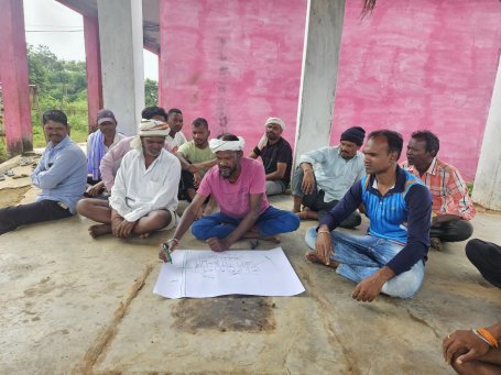
To raise awareness about the impacts of climate change and support the integration of local knowledge into formal planning processes, WRI India held a series of climate action prioritisation (CAP) workshops in Betul district. We brought together district officials, block-level departments and Panchayati Raj Institution (PRI) members to identify the impact of climate hazards on local communities and livelihoods.
Their observations revealed patterns that climate data alone could not capture. Community members highlighted locations where borewells had failed despite repeated investments, while identifying low-lying areas that continued to hold water through the summer. Forest officials observed that wildlife movement routes should be considered when planning water conservation projects to ensure that wild animals can secure access to water during the summer months. Such place-based knowledge helps validate climate risks, assess the feasibility of interventions, and identify solutions that are better suited to local conditions.
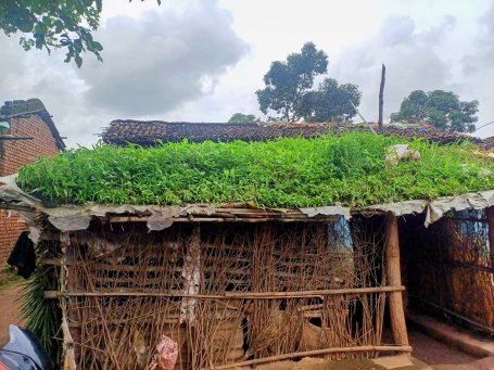
Local communities offered practical, context-specific adaptation solutions, such as improving plantations to strengthen groundwater recharge or using low-cost solutions like “green roofs” over cattle sheds to tackle heat exposure.
At the block level, officials highlighted opportunities to align climate priorities within existing government programmes. They emphasised the potential for scheme convergence, such as linking drought resilience efforts with water conservation structures under the erstwhile MGNREGA, promoting micro-irrigation through Pradhan Mantri Krishi Sinchayee Yojana (PMKSY), and integrating forestry and livestock strategies to address fodder shortages. Community institutions like Self-Help Groups (SHGs) and Van Suraksha Samitis (VSS) emerged as potential anchors for implementing and monitoring natural resource management and livelihood diversification activities.
The Betul experience emphasises how community knowledge, when combined with localised climate data, can reinforce development planning and bridge gaps across different levels of governance. While local resilience calls for a thoughtful understanding and leveraging of existing resources, it also calls upon different departments to work together and utilise development schemes to the fullest for sustained, system-wide resilience outcomes across India’s villages.