Is urban India going underwater again?
by e -
India is in the middle of the 2020 monsoon season and the Indian Meteorological Department has forecast a normal monsoon. But regional rainfall variations have already flooded rural and forest regions in Assam and Bihar. With heavy rains also occurring across many cities, the tension is ripe about urban areas. Will Urban India go underwater again?
Grey stormwater infrastructure such as drains, pumps and outfalls are frequently overwhelmed by extreme rainfall events or high levels of stormwater runoff from roads and streets. Not just Indian cities like Bengaluru, Delhi, Hyderabad, Mumbai, and Surat, but many cities in the global south are flooding frequently. With multiple, recurring failure of grey infrastructure globally, alternatives are now being sought. Natural ecosystems such as lakes, floodplains or parks, forests -are nature-based solutions (blue-green infrastructure) and offer flexible, low-cost solutions for flood mitigation and management and offer multiple co-benefits.
Urban flood management in India continues to focus only on improving grey infrastructure, rescue and relief, instead of building sustainable solutions to increase resilience. Cities continue to extend/expand stormwater networks, clean/de-silt channels and separate sewage and stormwater drains. These are all necessary activities and cities bear high costs to build stormwater (grey) infrastructure; but repeated floods indicate that these actions are insufficient. Three factors are identified here as major reasons for persistent urban flooding across India.
1. Building in the path of floods
During rain events urban development including public infrastructure (bus depots, roads, metro rail, airports, etc.) located on low-lying areas (floodplains, lake beds) face increased flood risk. Such areas are typically high recharge zones as water drains into these vegetated, low-lying locations, following the gradient of the land.
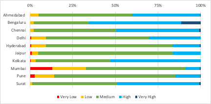
Preliminary findings from an on-going research project at WRI India indicate that in India’s 10 most populous cities (study cities are: Ahmedabad, Bengaluru, Chennai, Delhi, Hyderabad, Jaipur, Kolkata, Mumbai, Pune, Surat), 35% (428 sq.km) of new urban development added between 2000-15 (within 20 km of the city centre) has been on (low-lying, vegetated) high and very high recharge potential zones (Figure 1). All these cities have seen multiple flood events in the past five years.
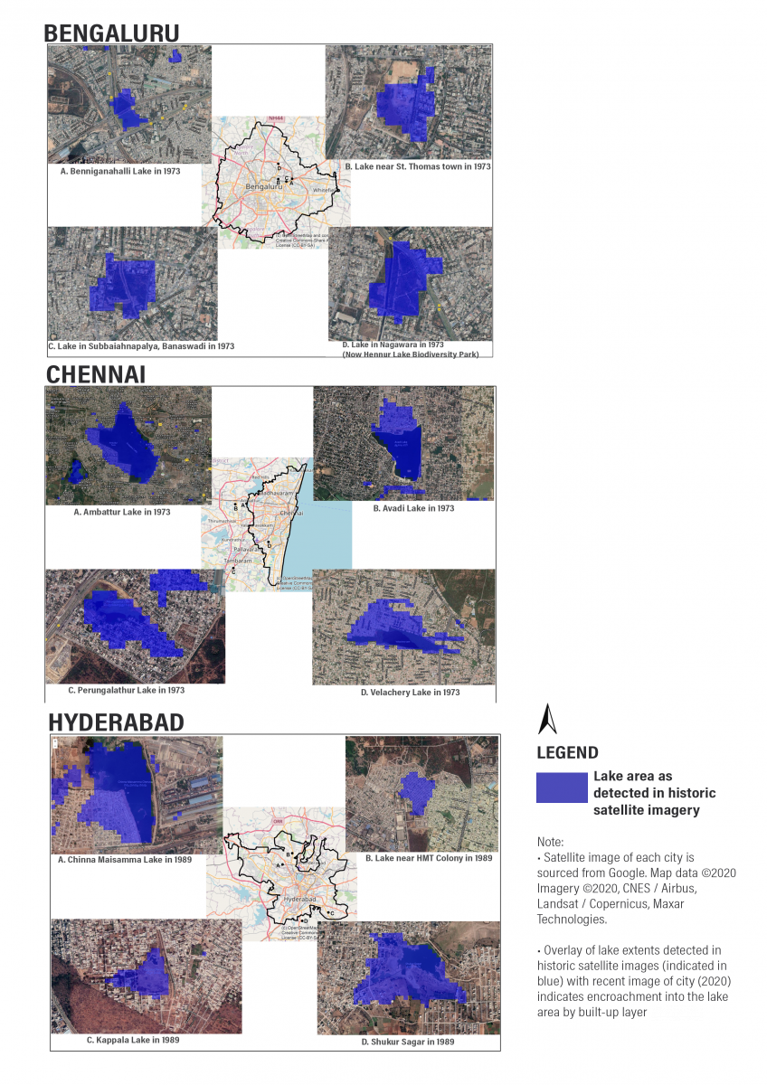
Space like lakes, wetlands, forests function as natural infrastructure absorb stormwater, reduce runoff volume and speed, thus, reducing flood risk. Destruction and encroachment of these spaces deteriorates the natural flood defense of cities. Analyzing satellite imagery of select locations (Bengaluru, Chennai, and Hyderabad) shows that between 1970-2020, lakes have shrunk or been replaced by roads, residential neighborhoods or playgrounds. Such locations routinely flood as stormwater drains into these low-lying areas.
2. Paving the way for floods
Rainwater infiltrates into the ground, flows as surface runoff and evapotranspirates into the atmosphere. Urban areas with impervious surfaces eliminate infiltration, reduce evapotranspiration, thereby drastically increasing surface runoff. A study in the United States indicates that for every 1% increase in impervious surface area there is a 3.3% increase in urban flood magnitude.
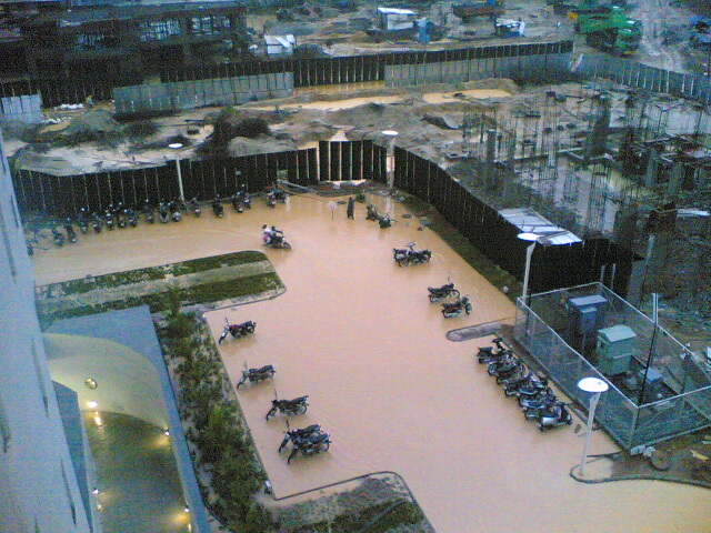
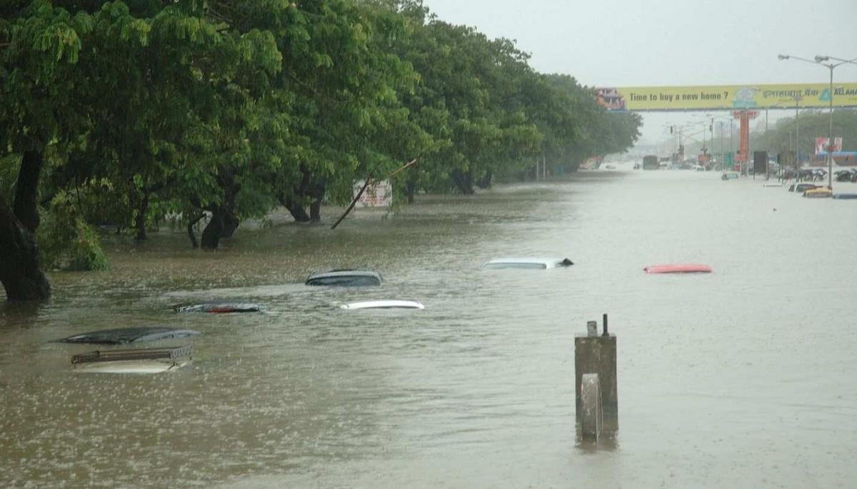
Urban India is continuously adding buildings, roads, flyovers for urban dwellers, often without adequate stormwater infrastructure. Large volumes of stormwater stagnate on these impervious surfaces causing repeated flooding.
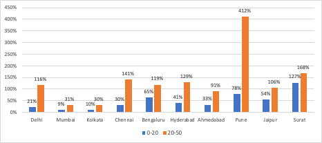
WRI India’s on-going research indicates that built-up cover has increased by 47% in 0-20 km of the city center (9% in Mumbai to 127% in Surat); built-up cover increased by 134% in 20-50 km from the city center (30% in Kolkata/Mumbai to 412% in Pune). Most of the 10 cities have flooded repeatedly over the last five years (2015-2020) and paved spaces like large parking lots, roads, underpasses are particularly prone to frequent and severe waterlogging.
3. Storms of uncertainty
Climate change driven rainfall variability is increasing with rainfall equivalent to monthly/seasonal averages falling within a few days. This year (2020) Mumbai received 80% of its average July rainfall in eight days. The devastating 2018 floods in Kerala were triggered by rainfall in excess of 200% of the state’s seasonal average, most of the rain falling within a week. The Chennai floods in 2015 were preceded by 345mm of rainfall recorded on December 1 (average December rainfall for Chennai is 191mm).
Floods have high economic and social costs. Damage from the Kerala floods are estimated at USD 3.56 billion (INR 27 thousand crore) and Chennai flood losses around USD 3 billion (INR 22 thousand crore). WRI Aqueduct platform’s flood analyzer tool estimates that by 2030, 34 million Indians will be at risk from riverine flooding (up from 12 million in 2010).
From reacting to building resilience
Alongside infrastructure expansion and upgrades the official response to floods now seeks to build robust rainfall and flood warning systems like in Chennai and Mumbai. Cities are also creating interactive maps of flood-prone zones (Bengaluru). These measures are still reactive; at best they enable evacuation of people and support effective deployment of rescue and relief measures. While undoubtedly essential measures, these do not proactively prevent floods and mitigate against loss to life, property and physical and social infrastructure.
An urgent reassessment of stormwater and cloudburst management is required in India. Depending solely on last century’s inflexible expensive grey infrastructure is insufficient to manage extreme weather events of today and those expected in the future.
Globally, grey infrastructure alone is unable to manage stormwater; cities are choosing green (or grey + green) infrastructure to manage urban flooding. Studies indicate green infrastructure measures for stormwater management are cheaper and offer more co-benefits than upgrading, expanding or retrofitting traditional grey infrastructure systems. Urban planning is shifting towards water prudent urban development and cities are adopting a hybrid approach of integrated green and grey infrastructure solutions at (local) street, neighborhood and (larger) city scale to build flood resilience.
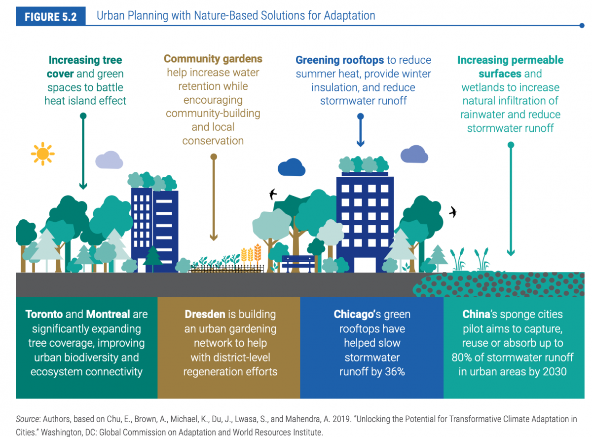
Floods cause significant life, livelihood and economic loss and erode developmental dividends that city authorities/government accrue through decades of hard work. Water prudent urban development coupled with integrated green and grey infrastructure can significantly increase a city’s resilience to urban floods. Neglecting such hybrid approaches and constructing only grey (stormwater) infrastructure to resolve urbanization and climate change driven stormwater issues will frequently bring Indian cities under water.
Part II of this blog will offer insights and examples of nature-based solutions for flood management implemented globally and also showcase emerging examples from India.

