


A Data-Informed Approach to Siting Agrivoltaics in India
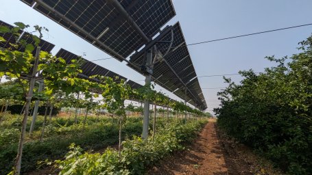
Nestled in the mustard and wheat fields of Issapur, on the outskirts of Delhi, a 4-metre-high agrivoltaics plant is reshaping how farmland is used. Spread over roughly four acres, the plant has enabled farmers to grow fruits, vegetables and spices, and rear livestock beneath elevated solar panels that have been generating electricity since 2021.
In Issapur, where agricultural activity has been steadily declining because of land degradation and out-migration, fields often lie fallow for most of the year; this solar plant presents a compelling land-use alternative. It allows for year-round use of farmland by co-locating energy generation with agricultural production, while also providing employment to farmers, who often have time to spare between sowing and harvesting.
Issapur’s plant is one of more than 36 agrivoltaics sites across 16 states, with a combined capacity estimated at more than 37 megawatts (MW) as of 2025. Earlier this year, the Ministry of New and Renewable Energy (MNRE) announced that the next phase of the Pradhan Mantri Kisan Urja Suraksha evam Utthaan Mahabhiyan (PM-KUSUM) will carry a dedicated 10-gigawatt (GW) agrivoltaics component.
Where these agrivoltaics projects are located can determine whether they offer meaningful benefits to farmers across small, medium and large landholdings. Since states differ widely in cropping patterns, landholding structures, grid network and market infrastructure, identifying the right sites for agrivoltaics projects requires looking beyond just solar potential.
Why Solar Potential is Not Sufficient Criteria
Unlike conventional solar projects, agrivoltaics enable the same land to support both energy generation (through solar photovoltaics) and crop production. An agrivoltaics site is therefore both an energy and an agricultural asset.
For farmers, electricity generated by the panels can provide an additional source of income when sold to the grid, while also supporting farm-level activities such as irrigation, e-tractors, cold storage and food processing units. However, site selection (or siting) is key to identifying projects that are most likely to deliver value to farmers.
Conventional solar assessments typically prioritise land parcels that receive abundant sunlight, are closer to the grid and have flat terrain. While these factors are important, a site with strong solar potential and proximity to a substation may still be far from agricultural mandis, cold chains or roads that connect farmers to markets.
Siting agrivoltaics must therefore consider both agricultural market access and energy infrastructure. This is particularly important where the local grid cannot absorb all the electricity generated by a plant because of substation capacity limitations or excess daytime supply. In such cases, surplus energy could support agricultural operations at the farmgate.

Geospatial mapping can help bring these considerations together. Several datasets already capture parts of this picture. The Pradhan Mantri Gram Sadak Yojana (PMGSY) portal, for example, includes geo-tagged rural facilities across India, including 1.53 lakh agricultural facilities such as mandis, warehouses and godowns. The Pradhan Mantri Kisan SAMPADA Yojana (PMKSY) has established 399 cold chain projects as of 2024. Integrating these spatial datasets can help identify locations close to agricultural markets and grid infrastructure, strengthening the economic case for dual land use.
Site Selection with Both Energy and Agricultural Factors
National GIS-based estimates place India’s agrivoltaics potential in the terawatt (TW) scale, with a broad range of 3.2–13.8 TW across 17 crops and 1–2 TW for horticultural crops. These estimates provide an important foundation for understanding how much agrivoltaics could technically be deployed. However, they use a similar stack of layers: first, isolating cropland from a land-cover map of India and then overlaying layers such as solar irradiance, slope and proximity to roads and substations. Each layer is assigned a fixed weight based on its relative importance to arrive at a suitable cropland area for agrivoltaics. Changing these criteria or adding locally relevant variables often requires that the analysis be rerun.
This is where the Energy Access Explorer (EAE) can help by bringing together supply and demand-side information relevant to agrivoltaics siting across agriculture and energy on a single, open-source interactive geospatial platform (figure 1).
From the energy-supply side, these include solar potential, slope and aspect (which indicates the direction a slope faces) and proximity to substations, transmission lines and roads. The platform also includes information on cropland, soil productivity and major crops grown, along with district-level agricultural data from the Ministry of Agriculture and Farmers’ Welfare.
Demand-side information includes cold chain facilities, agricultural mandis, and local demographics. These can be considered alongside environmental factors such as protected areas and flood-prone regions. As research on agrivoltaics advances, additional datasets can be added and existing information updated on the platform. The platform enables users to adjust the relative importance of different factors and customise site selection based on a combination of energy, agricultural, demand-side and environmental considerations, without requiring GIS training or paid software.
This can help a wide variety of stakeholders across the agrivoltaics value chain – including developers, farmer producer organisations, NGOs, civil society organisations, large landholders, farmers, renewable energy agencies and electricity utilities – assess site locations according to their needs.
Towards a More Context-Aware Agrivoltaics Siting
Scaling to 10 GW shifts the question from whether agrivoltaics has potential, which is now well established, to where it should be deployed. While EAE is not a substitute for ground-level validation, which needs to consider landholdings and local conditions, it can provide a useful starting point for identifying areas where future agrivoltaics projects could be sited. Given India’s ambition, EAE can support planning agencies in assessing locations across states, districts and agricultural fields, based on different objectives and available data.
National estimates have already established India’s potential. The next question is where to act first. EAE can help answer that by identifying the most suitable agrivoltaics locations based on different priorities, turning national potential into actionable project choices.
Projects
-
Energy Access Explorer
Part of Energy