


Living with Rivers: The Case of Bodoland
This is the third blog in a series that explores Bodoland through multiple lenses, including governance, economy, quality of life, ecology and culture, to emphasise the need for context-specific planning in ecologically-sensitive city regions. Read the previous blog in the series here.
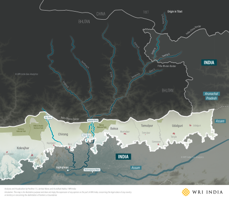
Located above the north bank of the Brahmaputra River, Bodoland is shaped by a network of Himalayan rivers that descend from the mountains of Bhutan and the Tibetan Plateau. Rivers such as the Manas, Aie, Beki, Sankosh and Gaurang flow through forests and foothills, often shifting their course across the floodplains. They sustain agriculture, fisheries and wildlife habitats, even as the region faces erosion and recurrent floods due to their fast-flowing waters.
For communities in Bodoland, rivers shape livelihoods and identity. Floodplains along these rivers support farming and inland fisheries, while wetlands and river corridors sustain biodiversity and the tourism economy.
Life on the Riverbank
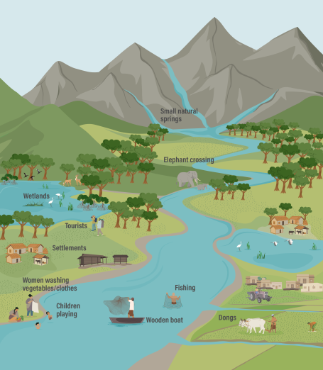
For generations, communities here have known how to bend with the river’s movement instead of resisting it. This is reflected in practices such as the traditional Dong system, an earthen network of channels carved into the foothills. Managed by local communities, it diverts water from rivers through canals to meet household and farming needs.
In riverine villages, the relationship between people and rivers is not merely practical; it’s woven into everyday cultural practice. Fishermen cast nets along quiet backwaters; children dive into shallow pools and people wash clothes at the riverbank. During the monsoon, when floods wash bridges away, wooden boats ferry people and baskets of produce across the river. Domestic and wild animals, including elephants, pause to drink at shallow bends as they move between the forests of Manas and Raimona.
These everyday scenes reflect how rivers shape not only livelihoods, but also movement, memory and a shared sense of place.
Origins: From Himalayas to Brahmaputra valley
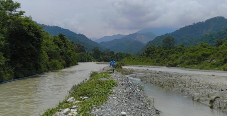
Bodoland’s rivers are fed by snowmelt and monsoon rainfall as they descend through steep valleys before entering the floodplains. In the hills, they flow narrow and fast, carrying large amounts of sand, gravel and silt. As they reach the gentler slopes of the foothills, the flow begins to spread.
In the plains, this reduced energy allows the rivers to form meanders — long, looping bends — that gradually shift across the floodplain as they move toward the Brahmaputra. As sediment continues to accumulate, channels become unstable, split into multiple strands and form braided patterns across wide, shallow beds. Closer to the foothills, where rivers first lose their energy, sediments build up into alluvial fans — broad, fan-shaped deposits of sand and gravel. This sequence is characteristic of Himalayan rivers and is clearly visible across Bodoland.
These changing forms are the natural response of Himalayan rivers adjusting to differences in slope and sediment. The shift from fast mountain streams to slower floodplain rivers creates constantly adjusting channels, making the rivers of Bodoland highly dynamic and prone to periodic shifts in their course. These changes directly influence where people can cultivate, settle, travel and access water. In some areas, riverbank erosion gradually consumes agricultural land and homes, while newly deposited sediments create temporary fertile patches used for seasonal farming.
Changing Courses and Shapes: Risks and Uncertainty
The Manas River — a major north-bank tributary of the Brahmaputra — flows through Tibet and Bhutan before entering India at Mathanguri in the Manas National Park, covering a total length of about 376 km. Here, the steep gradient flattens abruptly, triggering braiding, channel shifts and sediment deposition across the foothills of Baksa and Chirang.
It joins the Brahmaputra at Jogighopa in Assam. The Manas basin receives about 3,300 mm of rainfall annually, with nearly 75–80% concentrated during the monsoon months (May–September), leading to sharp seasonal variations in river discharge. As a result, river discharge during monsoon can be several times higher than in the dry season, driving flood dynamics in Assam and beyond.
Over time, the Manas River has shifted its course across the floodplains, carving new channels and leaving behind wetlands and alluvial deposits. These changes are driven by intense upstream monsoon rainfall, which increases runoff, discharge and sediment load. As sediment is deposited downstream, the river erodes its banks and readjusts its channel.
This creates compound risks, where rainfall in the upper catchment can lead to sudden rises in water levels in downstream districts like Baksa and Kokrajhar, even in the absence of local rainfall. Paying attention to these shifts is important because changing river trajectories affect settlements, roads, grazing areas, wetlands and wildlife movement corridors. Expansion of settlements and infrastructure into floodplains can further increase exposure to erosion and flood risks when rivers reclaim older channels during intense monsoon periods.
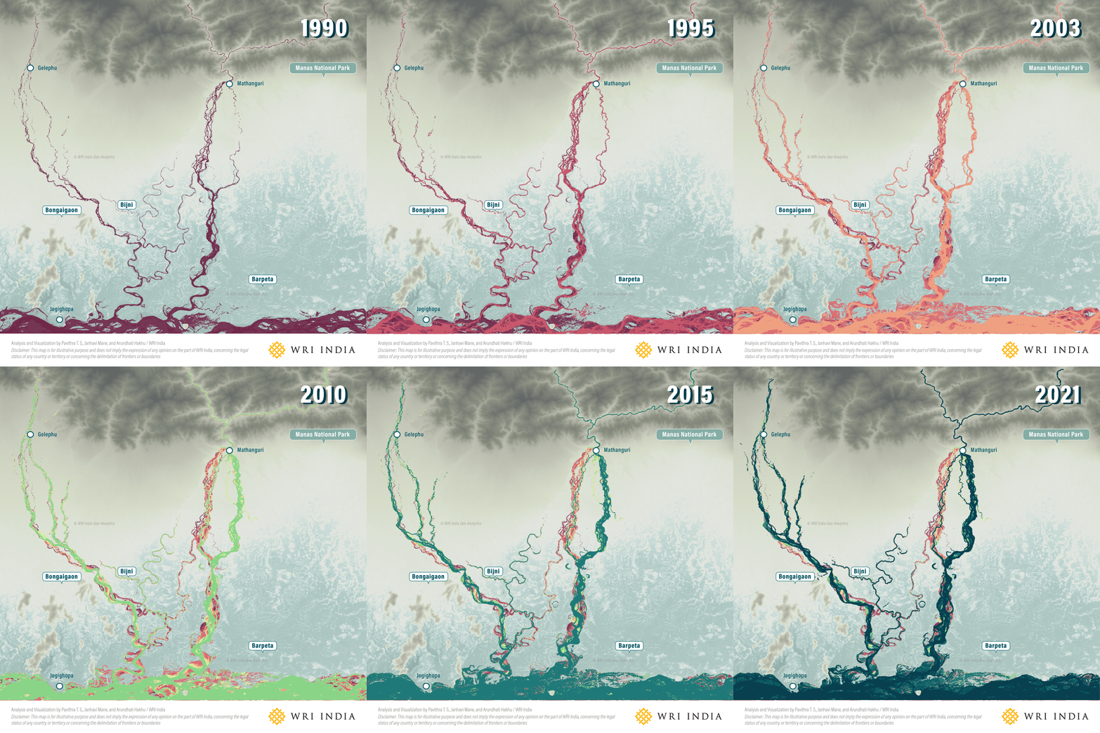
Bodoland is not just a region “affected” by forces of rivers; it is an ecosystem continuously shaped by them. Understanding how these rivers move, meander and flood is essential not only for reducing risks but also for sustaining the wetlands, forests and wildlife that surround them.
Much of the current development approach still treats rivers as fixed systems, even though Himalayan rivers naturally migrate across floodplains over time. Planning with rivers means aligning land use with the region’s ecological and geomorphic characteristics, protecting wetlands and floodplains from intensive construction, strengthening blue-green corridors, restoring traditional systems such as dongs, and designing settlements and infrastructure that can adapt to seasonal flooding and channel movement rather than resisting them entirely.
The challenge is not to control rivers, but to learn from them — recognising their natural processes as essential to both ecological balance and human survival. The way forward lies in planning with rivers rather than against them: giving space to floodplains, protecting riverine ecosystems and strengthening community-led approaches to living with the rivers.